


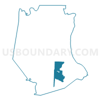
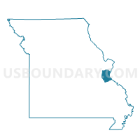
Athena Voting District, Jefferson County, Missouri
About
Outline

Summary
| Unique Area Identifier | 608789 |
| Name | Athena Voting District |
| County | Jefferson County |
| State | Missouri |
| Area (square miles) | 20.76 |
| Land Area (square miles) | 20.74 |
| Water Area (square miles) | 0.03 |
| % of Land Area | 99.86 |
| % of Water Area | 0.14 |
| Latitude of the Internal Point | 38.12518820 |
| Longtitude of the Internal Point | -90.45615760 |
Maps

Graphs
Select a template below for downloading or customizing gragh for Athena Voting District, Jefferson County, Missouri


Neighbors
Neighoring Voting District (by Name) Neighboring Voting District on the Map
- Airport No. 1 Voting District, Jefferson County, MO
- Hematite Voting District, Jefferson County, MO
- Jefferson R7-2 Voting District, Jefferson County, MO
- Oakvale Voting District, Jefferson County, MO
- Olympian Village Voting District, Jefferson County, MO
- Plattin Voting District, Jefferson County, MO
- Rush Tower Voting District, Jefferson County, MO
- Sunrise Voting District, Jefferson County, MO
- Valle No. 1 Voting District, Jefferson County, MO
- Victoria Voting District, Jefferson County, MO
Top 10 Neighboring County Subdivision (by Population) Neighboring County Subdivision on the Map
- Joachim township, Jefferson County, MO (18,838)
- River View township, Jefferson County, MO (16,567)
- Valle township, Jefferson County, MO (15,153)
- Central township, Jefferson County, MO (13,907)
- Plattin township, Jefferson County, MO (11,576)
Top 10 Neighboring Place (by Population) Neighboring Place on the Map
Top 10 Neighboring Elementary School District (by Population) Neighboring Elementary School District on the Map
Top 10 Neighboring Unified School District (by Population) Neighboring Unified School District on the Map
Top 10 Neighboring State Legislative District Lower Chamber (by Population) Neighboring State Legislative District Lower Chamber on the Map
- State House District 103, MO (39,604)
- State House District 110, MO (37,588)
- State House District 104, MO (35,833)
Top 10 Neighboring State Legislative District Upper Chamber (by Population) Neighboring State Legislative District Upper Chamber on the Map
Top 10 Neighboring 111th Congressional District (by Population) Neighboring 111th Congressional District on the Map
Top 10 Neighboring Census Tract (by Population) Neighboring Census Tract on the Map
- Census Tract 7010, Jefferson County, MO (8,574)
- Census Tract 7014.04, Jefferson County, MO (5,949)
- Census Tract 7009, Jefferson County, MO (5,340)
- Census Tract 7014.03, Jefferson County, MO (3,920)
- Census Tract 7014.01, Jefferson County, MO (3,918)
- Census Tract 7013, Jefferson County, MO (3,588)